


Scenic wilderness overnighter, with some challenging paddling.
The Ngaruroro Lower Gorge, from Kuripapango to Whanawhana, has a long history as an overnight kayaking run. (See the Riverguide.co.nz kayaking writeup)
This 39km section includes a rocky gorge containing more challenging whitewater than in the upper river. The gorge provides just enough excitement for advanced paddlers at low to medium packrafting flows. Hugh Canard described it as a sneaky one that slowly intensifies with each successive rapid, affecting uninformed packrafters like the proverbial boiling frog.
Thanks to Martin Robertson for the initial write-up and photos, Dan Clearwater for updates and edits.
View Larger Topographic Map
Planning
Trip duration
The Lower Gorge is best packrafted as an overnight trip, but throw in some trout fishing, and you can make it a pleasant and leisurely three-day trip. You might also allow three days if running it with paddlers who need to portage the heavier rapids.
The Lower Gorge is most commonly paddled as weekend trip, but can make a great 2-day addition to the Upper Ngaruroro run, creating a five day paddle from Boyd Lodge to the farmland.
Where to stay?
The Kuripapango (Ox Bow) DOC campsite is a convenient spot to spend the night after doing the shuttles.
There’s options to camp just before, within and just after the crux Rocky Gorge. The newly refurbished and relocated 6-bunk Komata Hut is also just before the Rocky Gorge. It is about 10 minutes walk above the river.
Gauge
The gauge is Ngaruroro at Kuripapango.
Recommended flows for packrafting are less than kayakers would aim for.
- 10 cumecs or less gives Class II+/III with a few portages.
- 10-15 cumecs means most of the rapids are filled in enough to paddle.
- 20 cumecs seems to be a good level for experienced Class III paddlers
Higher flows mean tougher rapids and mean hydraulics at the Barricade rapid.
Martin’s trip at 10 cumecs took 14 hours paddling time with lots of scouting and three portages. Travel would be faster for appropriately skilled and experienced teams at higher flows
Shuttle
Getting to the put-in
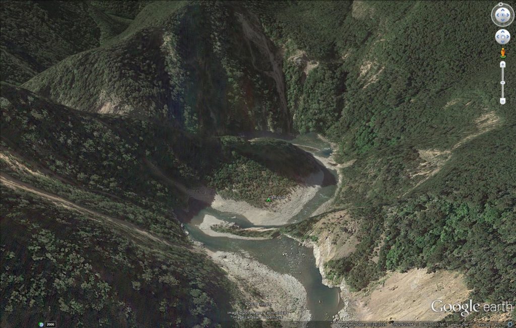
Access to the put in is off the Napier Taihape Road at Kuripapango. Kuripapango is about halfway between Napier and Taihape. About 200 metres west of the Ngaruroro bridge is a grassed rest area with a 4WD track leading down onto a lower terrace. You will find a walking track leading down the last 50 metres to the river. Or, if camping overnight after the drive, there is a put in at the Kuripapango camping ground a few km north. This is a more pleasant camp with toilets and lots of campers and probably less potential for interference with vehicles. There is a nice track 100m down to the river.
Getting to the take-out
Head east from Kuripapango towards Napier until Otamauri. Turn right at the junction at Otamauri and follow the gravel road to the junction with Whanawhana Road. Turn right and drive about 1.5 kilometres to the bridge over Otamauri Stream. Leave your vehicle here. Just beyond the bridge, a vehicle track on the left leads down to the river. This a fishing access, enabled by the good grace of landowner Bill Beamish.
Be sure to go down to the river so you know what it looks like from the water. It isn’t obvious, so a GPS mark and/or cairn marker is handy insurance. There can be quite a bit of traffic onto the riverbed at this point but it feels reasonably secure.
There is another take-out upstream that avoids some braided shallows but it crosses private land and getting permission is difficult.
On the Water
If doing as an overnighter you can put-in from the Kuripapango Campsite, above the “Ox-bow” section which adds an hour of Class II paddling through the ‘Ox-bow’ section. Or you can start at the Kuripapango bridge.
From Kuripapango the river flows down a narrow gorge, containing numerous Class II to II+ rapids for the first 10 km or so. This section of the river is through manuka scrub and steep dry greywacke country with abundant slips. There is a distinct feel to the upper gorge and the march of wilding pines is evident (pull a few out whilst you’re passing through). This upper section is a really fun warm up for what’s ahead.
Plan your overnighting spot carefully…
A few campsites can be found on terraces above the river in this first section. The best campsite there is at an outcrop of the Comet Fault (aka upper Rafters Camp) shortly before you enter the Rocky Gorge. It is on a rare river-right terrace a few metres above the river and has a rock cairn and road cone (as of 2024). There is lots of room.
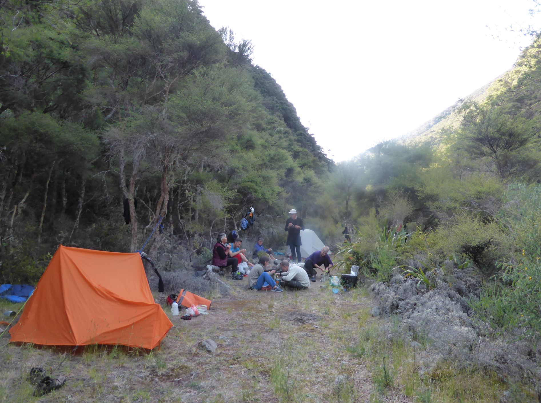
A scramble up to a higher terrace (10 minutes) takes you to Komata Hut, refurbished and relocated by Megan Dimozantos and the Backcountry Huts Trust with packrafters in mind.
The next decent campsite is the Island campsite, located in the Rocky Gorge itself, about 3hrs from the upper Rafters Camp. The Lower Rafters Camp is shortly after gorge (and the technical paddling) ends. Consider your energy, daylight hours and team before choosing where to spend the night.
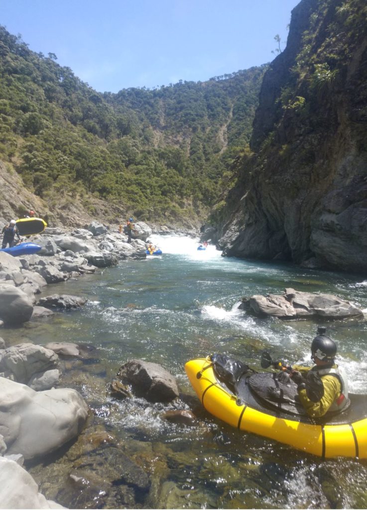
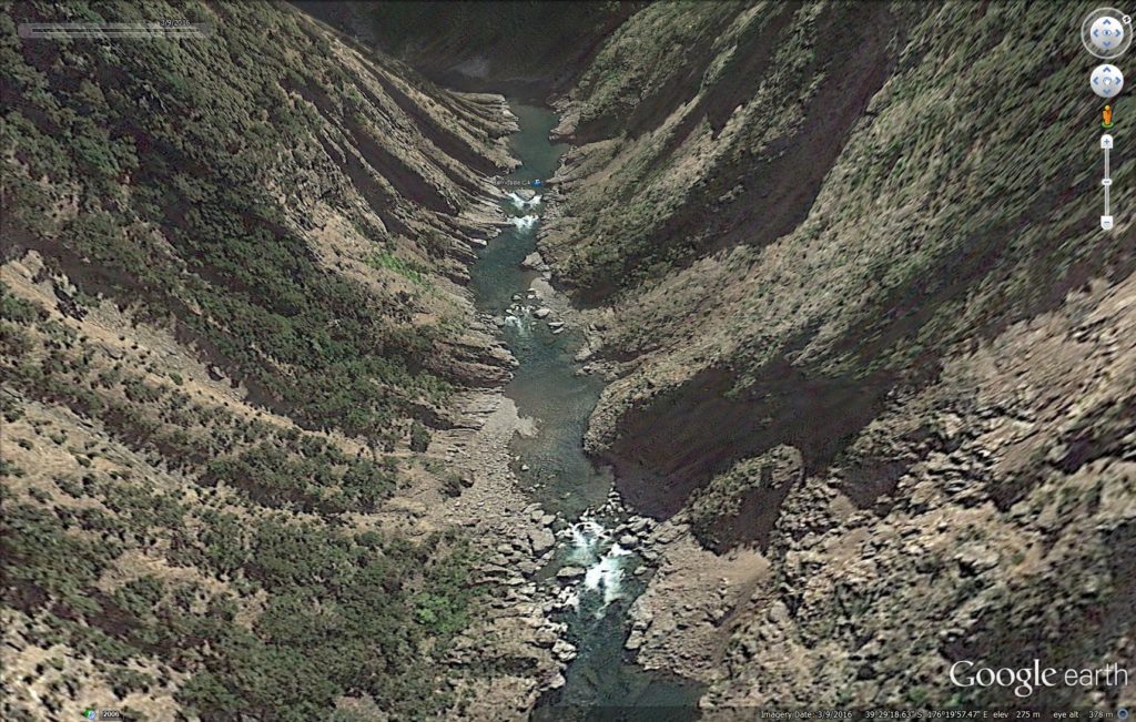
The Rocky Gorge (III+/IV)
After the upper Rafters Camp, the river enters the 9 km Rocky gorge.
The gradient increases progressively, particularly from the “Rock Garden”, and the intensity creeps up a little with each rapid.
“Gabby” is a tricky steep rapid courtesy of Cyclone Gabrielle. Shortly after, the Island campsite can be found just before the crux section, on river right. Island campsite is just before the river splits around a gravel island which is visible on the satellite imagery.
From here most packrafters should be shore scouting everything until the end of the gorge, but remember that all these gorge rapids are portageable. Just allow time in your trip plan if you have paddlers who will be portaging all of the four Class III+/IV rapids.
After Island campsite is the “Rock and Roll” rapid where the river passes left of a large rock in a narrow chute firing current at a wall that will roll the unwary.
A little further on and it’s “Double Drop” a series of two small drops that can only be portaged with difficulty but are straight-forward.
Then a waterfall on river left heralds the approach to “The Barricade” which is class IV in higher flows. Eddy out river left to scout. “The Barricade” is a narrow rock passage recognizable by the large midstream rock that forms a barricade and splits the river into 2 narrow chute drops. Check for wood! There is an easy portage on river left.
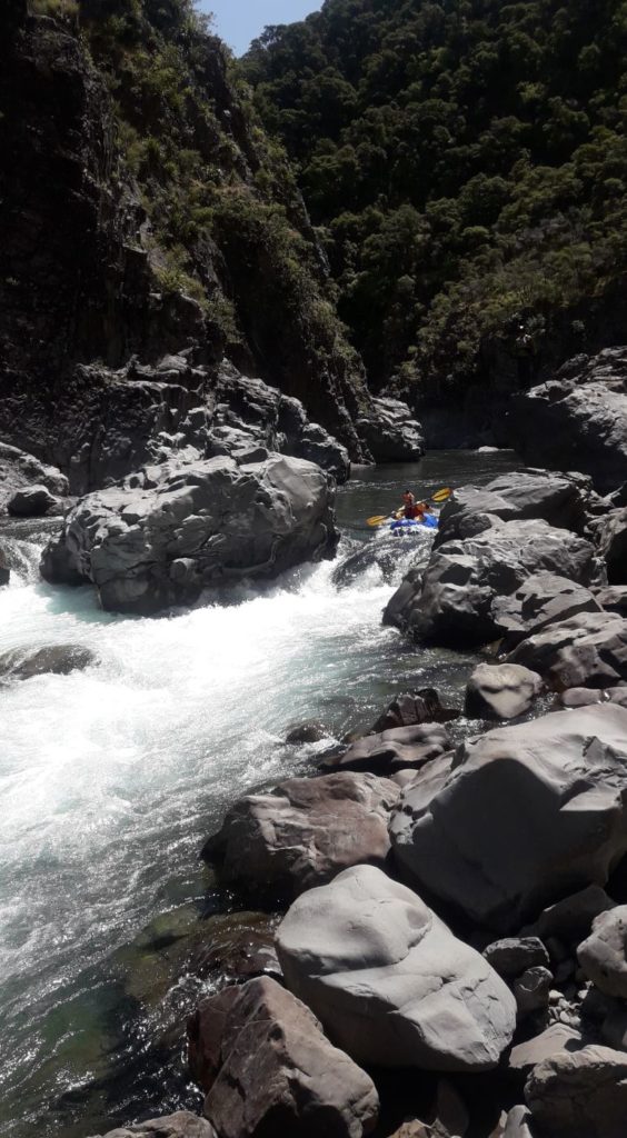
“Barrier Falls” follows 100m or so downstream. Portage on river left or scout it from both river left and right before you run it to check for wood. Again the drop is marked by a large rock that splits the flow. The rock sieve on river right has been washed out by Gabrielle and the center-line drop seems to be smaller.
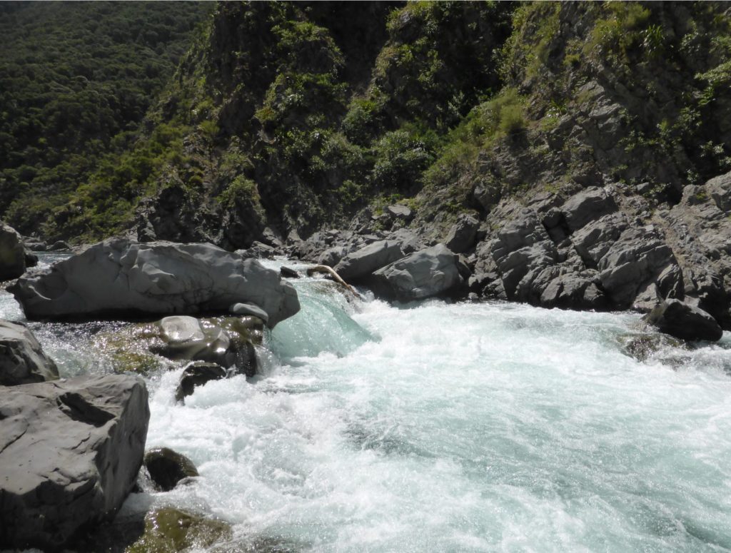
“Barrier Falls” at less than 10 cumecs could be too boney to run. Above this flow the drop will lessen but a big hole develops. There is a safe run out to a pool below it.
Below “Barrier Falls” the river eases markedly to Class II to II+. About a kilometre further on, there is good camping and lots of space at the Lower Rafters Campsite, on river right.
The river continues at Class II until the Taruarau confluence and then becomes Class I to II. It becomes progressively more open before becoming fully braided 5km above the take-out. Beware of willows on this section down to the Whanawhana takeout.